
AI-Powered Infrastructure Growth Analysis Using Satellite Imagery and GIS
Introduction
Infrastructure is the backbone of economic progress-shaping how cities grow, industries thrive and communities connect. As urbanization accelerates across the globe, construction and development are happening at unprecedented speed. Monitoring this surge is crucial for urban planning, investment strategy and sustainable development. Yet, traditional survey methods like manual field inspections or on-ground data collection are slow, expensive and often outdated. This is where Artificial Intelligence (AI) steps in. By combining satellite imagery, remote sensing and Geographic Information Systems (GIS), AI provides real-time, data-driven insights into how our built environment evolves.
At AI India Innovations, we explore how AI-powered analytics are enabling smarter, faster and more sustainable infrastructure growth-revolutionizing how cities and governments make planning decisions.
What is Infrastructure Growth Analysis?
Infrastructure growth analysis involves tracking and understanding the expansion of physical assets such as:
- Roads and highways
- Residential and commercial buildings
- Bridges and tunnels
- Industrial and utility zones (power, water, telecom)
Traditionally, this relied on manual surveys and static records. Today, AI automates and enhances this process, converting millions of satellite image pixels into actionable intelligence that reveals how cities expand and landscapes transforms.
How AI Monitors Infrastructure Growth
AI integrates machine learning, computer vision and geospatial analytics to detect, classify and predict changes in the built environment.
Here are four core techniques driving this transformation:
[A] Satellite Image Analysis
High-resolution satellite imagery provides a bird’s-eye view of urban and rural development. Using Convolutional Neural Networks (CNNs), AI models can classify pixels into land-cover categories such as buildings, roads, vegetation, or water.
Example:
- Before Construction (2010): Open land or farmland
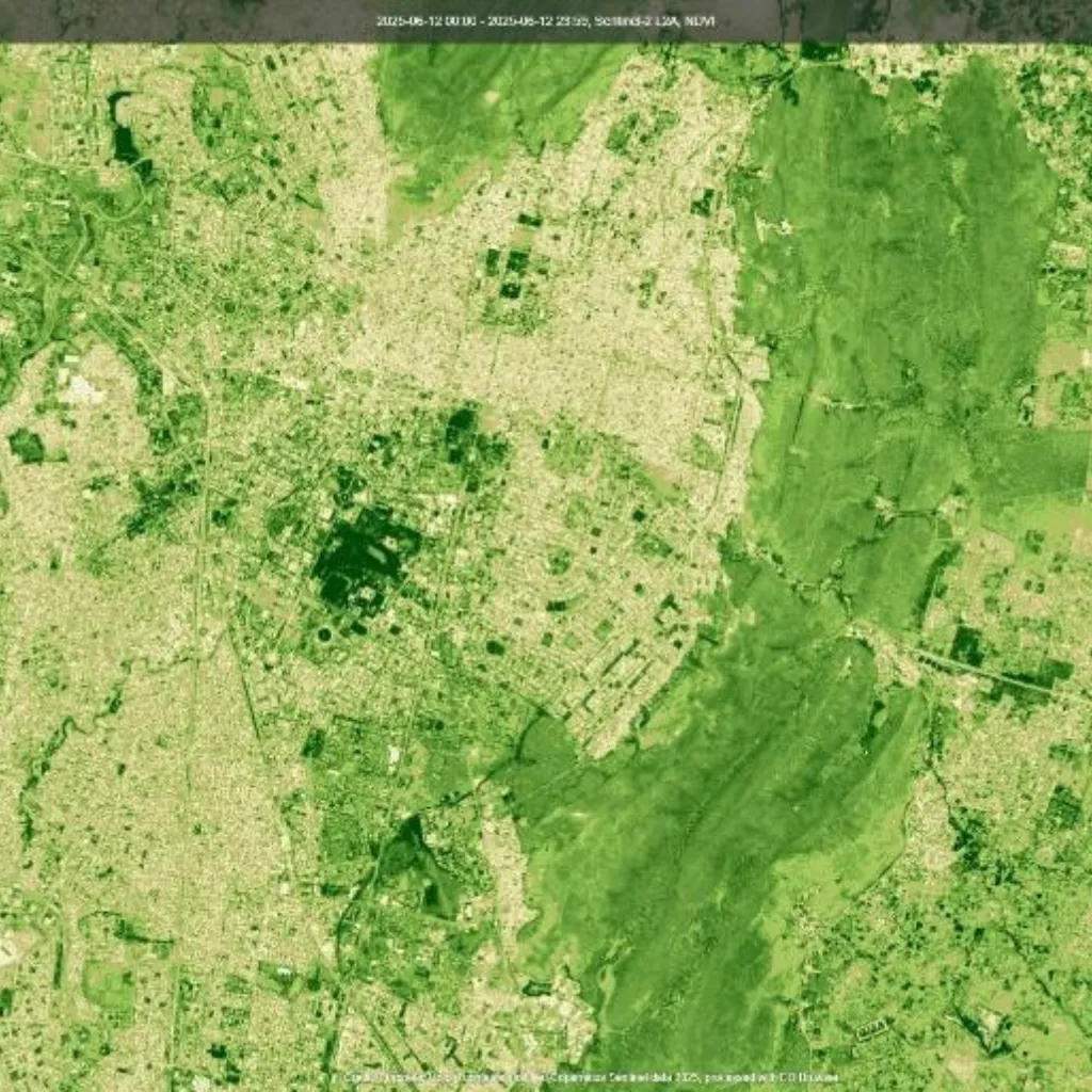
- After Construction (2025): AI automatically detects new roads, housing, or industrial zones.
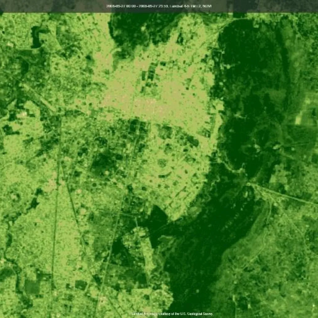
Before 2010
Same City From 2025
Technique Used: CNN-based land cover classification models analyze temporal imagery to detect infrastructure expansion patterns automatically.
[B] Change Detection
Change detection algorithms compare satellite images captured at different times to identify newly built, modified, or demolished structures.
Example Workflow:
| Steps | Description |
|---|---|
Step-1: |
Collect satellite images from two time points (e.g., 2010 vs. 2025) |
Step-2: |
Pre-process images-resize, normalize and align |
Step-3: |
Apply AI models to detect and classify infrastructure elements |
Step-4: |
Compare outputs to visualize new or removed structures |
Outcome:
Accurate visualization of urban expansion, redevelopment zones and loss of green cover-all derived from automated satellite analysis.
2017:

2025:

[C] Predictive Analysis
Beyond detection, AI can forecast future infrastructure growth using historical imagery, urban density metrics and socio-economic data. Using models such as LSTM (Long Short-Term Memory) neural networks, AI predicts which regions are likely to see accelerated development in the coming years.

Output:
Predictive heatmaps that highlight potential growth hotspots, helping urban planners and investors make proactive, data-driven decisions.
[D] Integration with GIS Platforms
AI insights integrate seamlessly with Geographic Information Systems (GIS) for spatial visualization and planning.
City planners can overlay AI-detected construction data with:
- Population density maps
- Transportation and traffic networks
- Environmental and flood-risk zones
Example:
Overlaying AI-inferred construction data on GIS layers allows governments to plan roads, schools and public utilities while minimizing environmental impact and congestion.

Real-World Applications of AI in Infrastructure Monitoring
AI-driven infrastructure intelligence has diverse real-world applications:
- Urban Planning: Detect and manage fast-growing development zones.
- Environmental Protection: Identify encroachment into protected ecological areas.
- Investment Decisions: Pinpoint emerging real estate and industrial growth regions.
- Disaster Risk Management: Monitor overbuilt areas vulnerable to floods or landslides.
By combining AI with satellite analytics, governments and private enterprises can foster smarter, safer and more sustainable cities.
Challenges in Applying AI for Infrastructure Growth
While AI offers powerful capabilities, there are key challenges to address before widespread adoption:
- Data Availability: High-resolution, cloud-free imagery can be limited or costly.
- Model Precision: AI accuracy depends on region-specific training datasets.
- Ethical & Privacy Concerns: Responsible handling of sensitive geospatial and residential data is essential.
Addressing these challenges will unlock AI’s full potential for responsible and scalable urban development.
Conclusion
AI is transforming how we monitor, analyze and predict infrastructure growth-replacing outdated surveys with real-time intelligence derived from satellite data and geospatial analytics.
For governments, urban planners and investors, AI delivers:
- Smarter, data-backed planning decisions
- Optimized resource allocation
- Predictive insights into city expansion
- Environmentally conscious development strategies
As cities evolve toward a data-driven future, AI-powered infrastructure intelligence will define the next era of urban growth-faster, smarter and more sustainable.
Partner With Us
At AI India Innovations, we empower organizations and governments to harness AI, satellite analytics and geospatial intelligence for infrastructure planning and smart city development. From detecting construction growth to predicting urban expansion trends, our AI-driven solutions enable evidence-based, sustainable decision-making for the cities of tomorrow. You can also check out our other Blogs to know the latest trends and our work in the field.
